
-
-
Nuclear radiation imaging Solution
-
Handheld gas nuclear radiation All-in-one solution
-
SETTALL low-altitude defense System solutions
-
Portable green laser bird repellent System solutions
-
Low-light aiming scope Solution
-
Multifunctional rapid screening instrument for drug abuse Solution
-
Photovoltaic and wind power complementary wireless monitoring System solutions
-
Road vehicle overheating warning System solutions
-
Laser-based bird deterrent system System solutions
-
Bird detection, monitoring, and dispersal System solutions
-
Mountain maintenance monitoring System solutions
-
New generation of coastal defense Solution
Solution
-
-
-
-
-

Solution
Solution
Handheld gas nuclear radiation
All-in-one solution
System solutions
Portable green laser bird repellent
System solutions
Solution
Photovoltaic and wind power complementary wireless monitoring
System solutions
Road vehicle overheating warning
System solutions
Laser-based bird deterrent system
System solutions
Bird detection, monitoring, and dispersal
System solutions
Mountain maintenance monitoring
System solutions
New generation of coastal defense
Solution
SETTALL low-altitude defense
System solutions
System Background and Introduction
This system is an advanced detection and defense system designed for urban security, key area protection, and other low-altitude combat missions. Its core objective is to perform round-the-clock, all-weather radar detection, photoelectric locking and tracking, precise positioning, and information reporting on various "low, slow, and small" targets, primarily unmanned aerial vehicles (UAVs). These low, slow, and small targets, such as drones, model airplanes, and hot air balloons, are inexpensive, stealthy, and difficult to detect and handle, making them ideal tools for potential hostile forces to carry out malicious activities. They pose a significant threat to the safety of large event venues and critical areas. Therefore, this system aims to ensure the safety and stability of these areas through efficient and precise detection and defense measures.
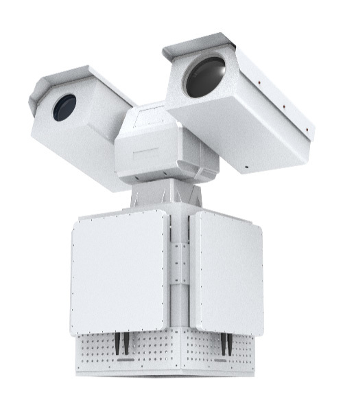
This system integrates multiple sensor technologies and can be configured with a search turntable/radar and a cooled tracking turntable to achieve all-weather seamless reconnaissance of key low-altitude areas. The SETALL photoelectric search unit, including an infrared thermal imager, can detect suspicious targets at 360° and issue alerts, guiding the tracking unit to lock onto the target while simultaneously providing target location information to the control center. The system is efficient and accurate, specifically designed to address the safety threats posed by low, slow, and small targets.
Core Functions
Multi-Method Detection, Photoelectric Tracking
This system uses a search turntable or radar for large-scale target search, combining target detailed investigation and judgment to achieve early detection, early warning, and rapid response to threats.
The search turntable or radar detects illegal mobile targets within the protected range in real-time, transmitting the latitude, longitude, speed, and direction of illegal targets to the system. The system automatically moves the turntable to the corresponding location, confirms the target, and automatically tracks it.
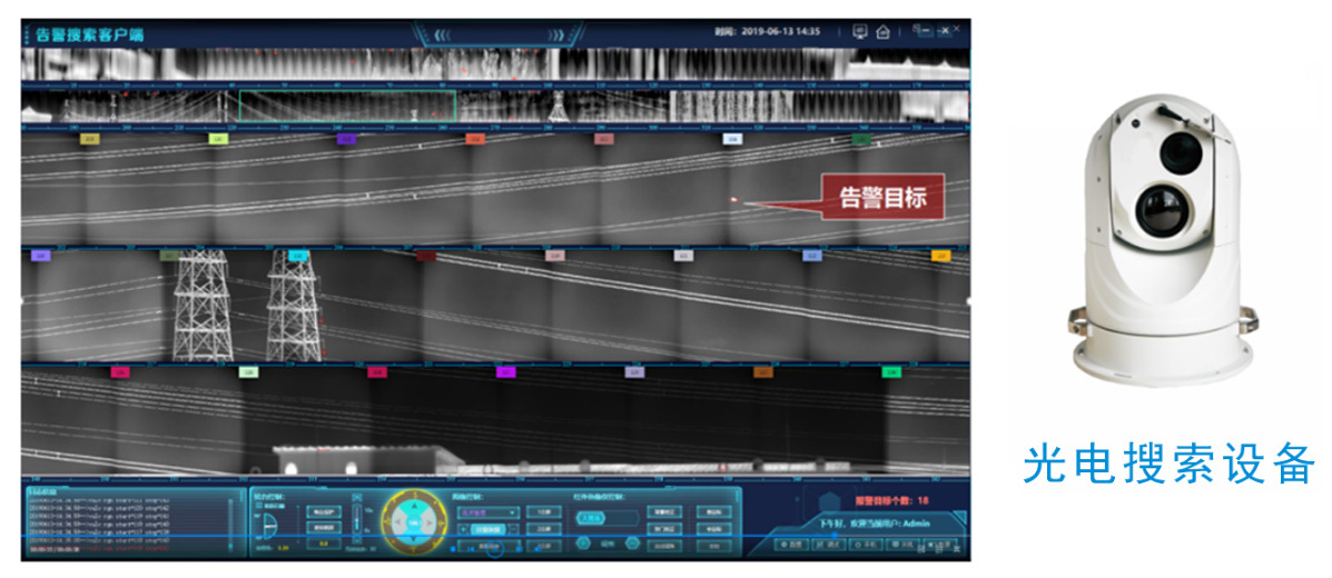
Deep Learning, Accurate Alarm
This system uses a search turntable or radar to detect small targets in low-altitude areas. The search turntable can detect and initiate tracking of small targets in a 360° airspace, using advanced target extraction algorithms to effectively filter out interference from clouds and birds.
After an alarm is triggered, the system automatically links a high-definition long-focus visible light system to perform secondary confirmation of the suspected target, automatically records the event, and achieves automatic detection and identification of targets in key low-altitude areas, accurately reporting important events. The system has the ability to independently think and make judgments.
Intelligent Algorithm, Target Correction
During target tracking, the system continuously compares the target's positioning information with the positioning information of targets sent by the radar in the same batch. Based on the comparison results, it determines whether the tracked target is accurate.
If the result indicates that the tracked target is incorrect, the system automatically guides the cooled tracking turntable to the latest positioning location sent by the radar, restarts detection, locks onto the target after detection, and tracks it. This achieves automatic correction of the tracked target, improving the system's intelligence.
Technical Highlights
System Composition
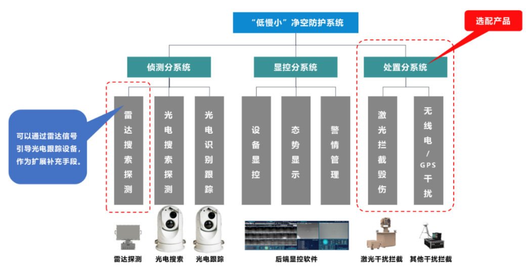
The display and control system commands a networked, digital, and information-based combat system, integrating operation control, unified coordination, air situation reception, data processing, situation fusion, and command combat functions to achieve effective detection and handling of targets.
Performance Indicators
Detection Targets:
Small rotorcraft UAVs (wheelbase 0.4~1.5m),
Small fixed-wing UAVs (wingspan 1~3m).
Detection Distance:
≥2km (small rotorcraft UAV, wheelbase 0.4m),
≥3km (small fixed-wing UAV, wingspan 1.4m).
Detection Range:
Azimuth range: 0°~360°;
Elevation range: -15°~80°.
Detection Performance and Equipment Technical Indicators:
Maximum detection speed: Airspace sweep time within a 15° elevation angle range is no more than 10 seconds;
Detection probability: ≥90%;
False alarm rate: ≤1 time/hour;
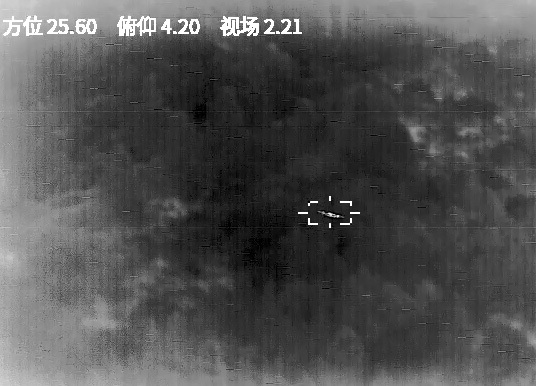
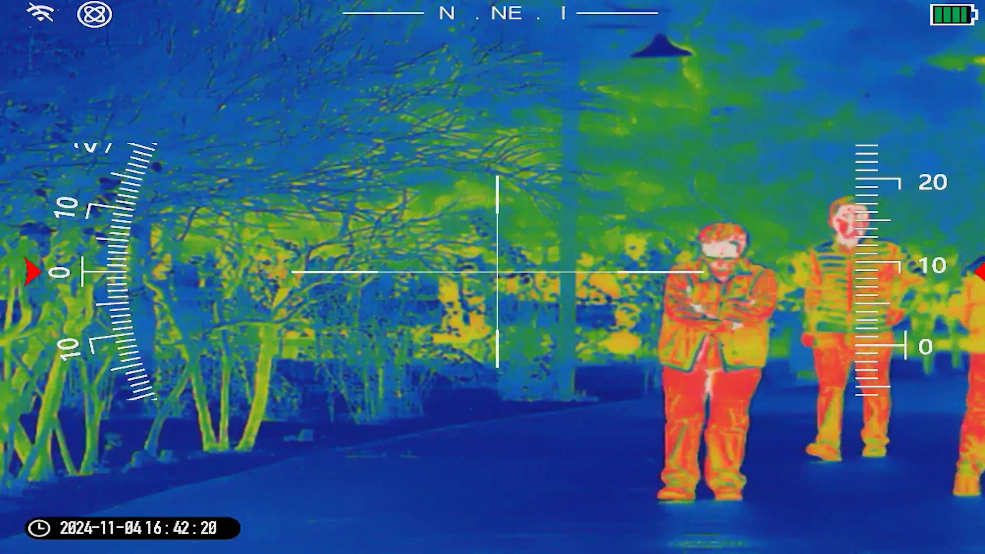
Photoelectric Detection of Low, Slow, and Small Targets
Sweeping or sector scanning acquires target intrusion information at 360° or in key areas. By detecting signals and images, the azimuth, elevation, and distance of the target are extracted to complete target orientation, track processing, display, output, and data reporting.
Radar Detection of Low, Slow, and Small Targets
The radar performs large-scale searches. Once the radar detects a suspected low, slow, and small target, it uses the radar's ranging and positioning functions to obtain information about the suspected low, slow, and small target and its location, and sends it to the system to trigger the system's alarm function.
The system will automatically link the photoelectric tracking equipment to confirm and track the suspected low, slow, and small target, displaying real-time video for remote control and detailed video examination by operators.
Intelligent Interlinked Photoelectric Tracking
The system fully utilizes the advantages of radar and photoelectric search to achieve seamless coverage of important low-altitude areas. By interlinking with cooled tracking turntables and other sensors, it achieves an organic combination of large-scale search and interlinked video composite detailed examination, performing large-scale search reconnaissance and accurate judgment of suspicious targets in parallel.
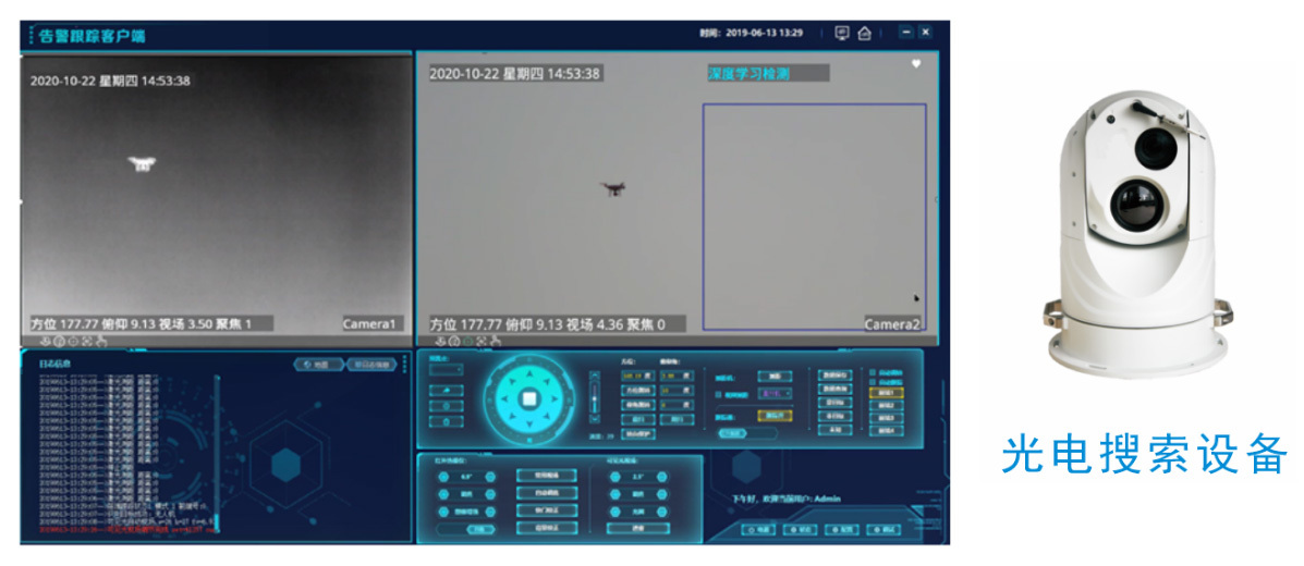
After the photoelectric or radar detects a suspected low, slow, and small target, it transmits the latitude, longitude, speed, and direction of the low, slow, and small target to the system. The system links the cooled tracking turntable to the target location, uses intelligent analysis to lock onto the target and then tracks it; simultaneously, it activates the deep learning algorithm to identify and classify the target, and takes different countermeasures based on different target types.
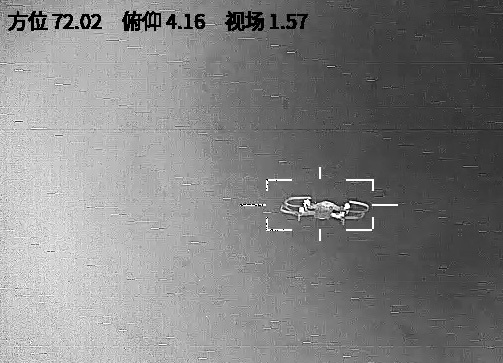
Target Locking
After the system links the cooled tracking turntable to the target location, it automatically activates the small target detection algorithm in the target area. After detecting the target, it automatically locks onto and starts tracking.
During tracking, the system controls the pan-tilt unit to continuously adjust the focal length of the lens according to the size of the target, ensuring that the target is always maintained at an appropriate size. For visible light cameras, it also ensures that the target details are clear enough for monitoring personnel to observe the target's detailed characteristics.
The tracking algorithm has a certain anti-interference capability. It can remain unaffected by occlusion, noise, and small differences between the foreground and background during target movement, achieving robust tracking results.
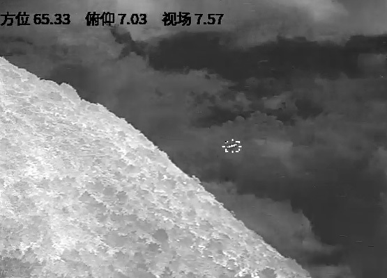
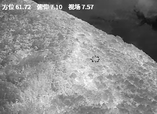
Detection and tracking after occlusion
If the target is lost due to severe occlusion during tracking, the system will restart the target detection algorithm. Once the target is found, tracking will automatically resume.
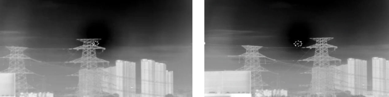
Tracking effect after occlusion (Left: Occlusion; Right: Continued tracking)
Incident Management
After the operator confirms that the alarm target is a dangerous target through photoelectric tracking, the type, location, and other information of the target can be reported to the command and control center through the system.
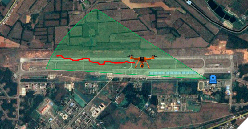
Taking a fixed-wing UAV target as an example, the system's protection area is as follows: the target is detected 2km from the protection area; identification and warning are completed before it flies to 1-8km from the protection area; radio/GPS jamming begins when it flies to 2km from the protection area.
Applicable Scenarios
Urban Safety:
High-rise building security protection: By monitoring and controlling the entry of UAVs and other aircraft, it effectively prevents potential malicious attacks or espionage activities, protecting the safety of high-rise buildings and their surrounding areas.
Public transportation facility security protection: Deployed around public transportation facilities such as subway stations, train stations, and bus stations, it monitors and eliminates threats from abnormal aircraft.
Border Security:
Border line monitoring: Conducting border patrols and surveillance using UAVs and other aircraft to promptly detect suspicious personnel, vehicles, or illegal items entering the country. Traffic control: Real-time monitoring of air traffic in border areas, including civilian and military aircraft, to ensure the safe and smooth flow of border airspace.
Combating illegal immigration and smuggling activities: Detecting illegal immigrants or smugglers using small UAVs and other equipment to infiltrate the national border, assisting law enforcement agencies in taking timely measures to combat them.
Important Facility Security:
Critical infrastructure protection: Continuously monitoring energy facilities, transportation hubs, communication base stations, etc., to promptly detect and respond to low-altitude threats, ensuring the safe and stable operation of infrastructure.
Counter-terrorism and Stability Maintenance:
Deploying a low-altitude defense system on the front line of counter-terrorism and stability maintenance, it can effectively monitor and deal with the behavior of terrorists using UAVs and other low-altitude aircraft for reconnaissance and attacks, improving counter-terrorism and stability maintenance capabilities.
Civil Aviation Safety:
Monitoring and controlling small aircraft, UAVs, and other aircraft to prevent unauthorized aircraft from entering controlled airspace, avoiding collisions with normally flying aircraft such as civil aviation aircraft, and endangering aviation safety.
Summary
The SETTALL low-altitude defense system solution integrates cutting-edge technology and innovative design concepts, providing comprehensive and efficient low-altitude defense capabilities for key areas such as urban security, border protection, and important facility protection. The system not only has powerful detection and tracking functions, but has also made significant breakthroughs in intelligence and automation, greatly improving the efficiency and accuracy of dealing with "low, slow, and small" targets.
By combining multiple detection methods and photoelectric tracking technology, the system can achieve all-weather, all-round monitoring, ensuring that no potential threat can escape its "eyes." At the same time, the application of deep learning algorithms enables the system to accurately identify and alarm, effectively avoiding false positives and missed reports, greatly reducing the workload of operators.
In addition, the SETTALL low-altitude defense system also has an intelligent algorithm target correction function, which can continuously compare and correct target information during tracking to ensure tracking accuracy. This function, while achieving precise strikes, also greatly improves the reliability and stability of the system.
In terms of technological highlights, the networked, digital, and informational characteristics of the system's composition make the combat system more efficient and collaborative. Excellent performance indicators, such as detection distance, detection range, and detection speed, fully demonstrate the system's leading position in the field of low-altitude defense.
In summary, the SETTALL low-altitude defense system solution, with its excellent performance, high level of intelligence and automation, and wide range of applications, has become an indispensable force in safeguarding national security and maintaining social stability. With the continuous advancement of technology and the continuous expansion of application fields, it is believed that the system will play an even more important role in the future.
Related Videos


Contact
EMAIL: Guojin@settall.com
No. 8, 14th Building, Zone 7, Headquarters Base, West Outer Ring Road, Fengtai District, Beijing

